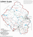
File:Mapa Górnego Śląska.png
Appearance

Size of this preview: 532 × 600 pixels. Other resolutions: 213 × 240 pixels | 426 × 480 pixels | 681 × 768 pixels | 908 × 1,024 pixels | 1,817 × 2,048 pixels | 3,650 × 4,114 pixels.
Original file (3,650 × 4,114 pixels, file size: 2.61 MB, MIME type: image/png)
File history
Click on a date/time to view the file as it appeared at that time.
| Date/Time | Thumbnail | Dimensions | User | Comment | |
|---|---|---|---|---|---|
| current | 13:22, 23 January 2022 |  | 3,650 × 4,114 (2.61 MB) | Gaj777 | drobne korekty |
| 19:29, 21 February 2021 |  | 3,659 × 4,114 (2.61 MB) | Gaj777 | translation corrected | |
| 01:12, 20 February 2021 |  | 3,683 × 4,114 (2.58 MB) | Gaj777 | Uploaded own work with UploadWizard |
File usage
No pages on the English Wikipedia use this file (pages on other projects are not listed).
Global file usage
The following other wikis use this file:
- Usage on pl.wikipedia.org


